INTERNATIONAL LIGHTHOUSE/LIGHTSHIP WEEKEND
|
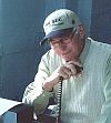 GM4SUC SK |
The following list contains lighthouses and lightships that have been active in the event since 2007.
And is the only OFFICIAL list of lighthouses and lightships used by the
International Lighthouse/Lightship Weekend
If your lighthouse is not on this list, go to the OFFICIAL ON-LINE ENTRY FORM and tell us about it.
Lighthouse: Generally regarded as a structure that is or has been listed officially as an aid to navigation in
a recognized publication such as the British Admiralty List of Light and Foghorns, and which falls into the
classic concept of a lighthouse. For example, a substantial tower having an internal staircase, a revolving
Fresnel lens and had or has a designated lighthouse keeper. Also permitted are lighthouses that have been
moved to a museum for historic reasons.
But, the fact that a light has been listed in official documents such as the "British Admiralty List of Lights and
Foghorns", the "USCG Light List", or the "NGA List of Lights, Radio Aids and Fog Signals", and for example,
on the ARLHS list of lights, does not automatically qualify the structure for this event. Such lights as range
lights, channel markers, skeletal towers, and breakwall lights will probably not be accepted. Examples of some
lights which have been submitted for the event, but which have been rejected can be seen on this web page.
Remember, the operation from faux or false lighthouses, lights on poles, lights that no longer exist, etc. is
discouraged as they are not within the spirit of the event.
*The DXCC entity comes from the current ARRL DXCC LIST.
The ILLW Numbers are assigned using the list of current Internet Top-level Domains (TLDs) as the prefix.
Lighthouses/Lightships by DXCC Country
Click on a Country name.
Click on a Country name.
ILLW Lighthouse List - Part 1 of 3 (Alaska thru France)
COUNTRY*
|
LIGHTHOUSE NAME |
DXCC |
Continent |
Map |
ILLW No. |
| Alaska | Rockwell | KL | NA | US0092 | |
| Alaska | Sentinel Island | KL | NA | US0082 | |
| Also See: Hawaii & U.S.A. |
COUNTRY |
LIGHTHOUSE NAME |
DXCC |
Continent |
Map |
ILLW No. |
| Algeria | Cap Falcon | 7T | AF | DZ0001 | |
| Algeria |
Cap Ivi / |
7T | AF | DZ0004 | |
| Algeria | Cap Ténès | 7T | AF | DZ0002 | |
| Algeria | Cherchell Fort Joinville |
7T | AF | DZ0003 |
| COUNTRY |
LIGHTHOUSE NAME |
DXCC* |
Continent |
Map |
ILLW No. |
| |
Puerto Madryn Deleted. This does not meet the requirements of the ILLW. |
||||
| Argentina | Año Nuevo / Isla Observatorio |
L0 | SA | AR0051 | |
| |
Deleted. This does not meet the requirements of the ILLW. |
||||
| |
Deleted. This does not meet the requirements of the ILLW. |
||||
| Argentina | Bahía San Gregorio | L0 | SA | AR0028 | |
| |
Deleted. This does not meet the requirements of the ILLW. |
||||
| |
Deleted. This does not meet the requirements of the ILLW. |
||||
| |
Deleted. This does not meet the requirements of the ILLW. |
||||
| |
Deleted. This does not meet the requirements of the ILLW. |
||||
| |
Deleted. This does not meet the requirements of the ILLW. |
||||
| |
Deleted. This does not meet the requirments of the ILLW. |
||||
| |
Deleted. This does not meet the requirments of the ILLW. |
||||
| |
Deleted. This does not meet the requirements of the ILLW. |
||||
| Argentina | Beauvoir | L0 | SA | AR0005 | |
| |
Deleted. This does not meet the requirements of the ILLW. |
||||
| Argentina | Cabo Blanco | L0 | SA | AR0006 | |
| |
Deleted. This does not meet the requirements of the ILLW. |
||||
| Argentina | Cabo San Antonio | L0 | SA | AR0018 | |
| Argentina | Cabo San Jorge | L0 | SA | AR0036 | |
| Argentina | Cabo Vírgenes | L0 | SA | AR0032 | |
| |
Deleted. This does not meet the requirements of the ILLW. |
||||
| Argentina | Claromecó | L0 | SA | AR0008 | |
| Argentina | El Rincón | L0 | SA | AR0009 | |
| Argentina | Golfo Nuevo | L0 | SA | AR0033 | |
| Argentina | Islotes les Éclaireurs | L0 | SA | AR0052 | |
| Argentina | Magallanes | L0 | SA | AR0047 | |
| Argentina | Martín García (Old) | L0 | SA | AR0022 | |
| |
Deleted. This does not meet the requirements of the ILLW. |
||||
| |
Deleted. This does not meet the requirements of the ILLW. |
||||
| |
Buenos Aires Outer Breakwall Deleted. This does not meet the requirements of the ILLW. |
||||
| |
Deleted. This does not meet the requirements of the ILLW. |
||||
| Argentina | Punta Delgada | L0 | SA | AR0042 | |
| |
Deleted. This does not meet the requirements of the ILLW. |
||||
| |
Deleted. This does not meet the requirements of the ILLW. |
||||
| Argentina | Punta Lobos | L0 | SA | AR0048 | |
| Argentina | Punta Médanos | L0 | SA | AR0012 | |
| Argentina | Punta Mogotes | L0 | SA | AR0013 | |
| |
Deleted. This does not meet the requirements of the ILLW. |
||||
| |
Deleted. This does not meet the requirements of the ILLW. |
||||
| Argentina | Punta Páramo | L0 | SA | AR0037 | |
| |
Deleted. This does not meet the requirements of the ILLW. |
||||
| Argentina | Quequén | L0 | SA | AR0015 | |
| Argentina | Querandí | L0 | SA | AR0034 | |
| Argentina | Recalada a Bahía Blanca / Bahía Blanca Landfall / Monte Hermoso |
L0 | SA | AR0016 | |
| Argentina | Río Negro | L0 | SA | AR0017 | |
| |
Deleted. This does not meet the requirements of the ILLW. |
||||
| Argentina | San Juan de Salvamento | L0 | SA | AR0050 | |
| Argentina | San Matías | L0 | SA | AR0039 | |
| Argentina | San Sebastián | L0 | SA | AR0044 | |
| Argentina | Segunda Barranca | L0 | SA | AR0019 | |
| Argentina | Stella Maris | L0 | SA | AR0020 |
| COUNTRY |
LIGHTHOUSE NAME |
DXCC* |
Continent |
Map |
ILLW No. |
| Aruba | Noordwestpunt / California / Hudishibana |
P40 | SA | AW0001 |
COUNTRY |
LIGHTHOUSE NAME |
DXCC |
Continent |
Map |
ILLW No. |
| Australia | Archer Point, QLD | VK | OC | AU0065 | |
| Australia | Ballina Head / Ballina / Richmond River, NSW |
VK | OC | AU0001 | |
| Australia | Barrenjoey Head, NSW | VK | OC | AU0046 | |
| Australia | Bluff Hill Point, TAS | VK | OC | AU0081 | |
| Australia | Bonnet Island, TAS | VK | OC | AU0134 | |
| Australia | Bradley's Head, NSW | VK | OC | AU0136 | |
| Australia | Bribie Island Range Front / Northwest Channel Range Front, QLD |
VK | OC | AU0057 | |
| Australia | Bribie Island Range Rear / Northwest Channel Range Rear, QLD |
VK | OC | AU0058 | |
| Australia | Bulwer Island Rear, QLD | VK | OC | Museum | AU0003 |
| Australia | Burnett Heads (New) / South Head, QLD |
VK | OC | AU0104 | |
| Australia | Burnett Heads (Old), QLD | VK | OC | AU0004 | |
| Australia | Bustard Head, QLD | VK | OC | AU0093 | |
| Australia | Caloundra Head (New), QLD | VK | OC | AU0120 | |
| Australia | Caloundra Head (Old), QLD | VK | OC | AU0025 | |
| Australia | Cape Bailey, NSW | VK | OC | AU0038 | |
| Australia | Cape Banks, SA | VK | OC | AU0121 | |
| Australia | Cape Borda, SA | VK | OC | AU0125 | |
| Australia | Cape Bowling Green (old), NSW Relocated to Australian National Maritime Museum. |
VK | OC | AU0137 | |
| Australia | Cape Bruny (New), TAS | VK | OC | AU0005 | |
| Australia | Cape Byron, NSW | VK | OC | AU0006 | |
| Australia | Cape Capricorn, QLD | VK | OC | AU0059 | |
| Australia | Cape Cleveland, QLD | VK | OC | AU0045 | |
| Australia | Cape Donington, SA | VK | OC | AU0130 | |
| Australia | Cape du Couedic, SA | VK | OC | AU0126 | |
| Australia | Cape Inscription, WA | VK | OC | AU0128 | |
| Australia | Cape Jaffa, SA Moved to the Cape Jaffa Lighthouse Museum located on Marine Parade in Kingston. |
VK | OC | AU0007 | |
| Australia | Cape Jervis, SA | VK | OC | AU0094 | |
| Australia | Cape Leeuwin, WA | VK | OC | AU0008 | |
| Australia | Cape Liptrap, VIC Special note: Operation from the Cape Liptrap lighthouse requires a permit (with fee) from Parks Victoria together with proof of public liability insurance and a supporting submission as to the composition of the station, numbers involved, and times of attendance. Camping in the lighthouse precinct or adjacent car park is not permitted. |
VK | OC | AU0037 | |
| Australia | Cape Martin, SA | VK | OC | AU0074 | |
| Australia | Cape Moreton, QLD | VK | OC | AU0009 | |
| Australia | Cape Naturaliste, WA | VK | OC | AU0010 | |
| Australia | Cape Nelson, VIC | VK | OC | AU0055 | |
| Australia | Cape Northumberland, SA | VK | OC | AU0122 | |
| Australia | Cape Otway Light Station (New), VIC | VK | OC | AU0011 | |
| Australia | Cape Schanck, VIC | VK | OC | AU0012 | |
| Australia | Cape St. George, NSW | VK | OC | AU0132 | |
| Australia | Cape Tourville, TAS | VK | OC | AU0119 | |
| Australia | Cape Wickham, TAS | VK | OC | AU0082 | |
| Australia | Cape Willoughby, SA | VK | OC | AU0095 | |
| Australia | Carnarvon, WA | VK | OC | AU0042 | |
| Australia | Casurina Point / Marlston Hill / Bunbury, WA |
VK | OC | AU0086 | |
| Australia | Cave Point, WA | VK | OC | AU0116 | |
| Australia | Citadel Island, VIC The lantern is now located at the Port Albert Maritime Museum, VIC |
VK | OC | Museum | AU0110 |
| Australia | Clarence Head, NSW | VK | OC | AU0013 | |
| Australia | Cleveland Point (New), QLD | VK | OC | AU0014 | |
| Australia | Corny Point, SA | VK | OC | AU0015 | |
| Australia | Crookhaven Heads, NSW | VK | OC | AU0047 | |
| Australia | Crowdy Head, NSW | VK | OC | AU0044 | |
| Australia | Currie, TAS | VK | OC | AU0016 | |
| Australia | Deal Island, TAS | VK | OC | AU0129 | |
| Australia | Eastern / McCrae, VIC |
VK | OC | AU0017 | |
| Australia | Eddystone Point, TAS | VK | OC | AU0087 | |
| Australia | Eddystone Point Front, TAS | VK | OC | AU0088 | |
| Australia | Emery Point, NT | VK | OC | AU0127 | |
| Australia | Endeavour / Henry Head, NSW |
VK | OC | AU0052 | |
| Australia | Entrance Island, TAS | VK | OC | AU0077 | |
| Australia | Evans Head, NSW | VK | OC | AU0018 | |
| Australia | Fingal Head, NSW | VK | OC | AU0115 | |
| Australia | Fitzroy Island, QLD | VK | OC | AU0064 | |
| Australia | Fremantle North Mole, WA | VK | OC | AU0073 | |
| Australia | Gabo Island, VIC | VK | OC | AU0080 | |
| Australia | Goose Island, TAS | VK | OC | AU0070 | |
| Australia | Grassy Hill, QLD Cooktown, QLD |
VK | OC | AU0019 | |
| Australia | Green Cape, NSW | VK | OC | AU0020 | |
| Australia | Griffiths Island, VIC / Griffith Island, VIC / Port Fairy, VIC |
VK | OC | AU0114 | |
| Australia | Guilderton, WA | VK | OC | AU0067 | |
| Australia | Hornby, NSW | VK | OC | AU0041 | |
| Australia | Iron Pot Island,TAS / Derwent, TAS |
VK | OC | AU0108 | |
| Australia | Island Point, QLD / Port Douglas, QLD |
VK | OC | AU0109 | |
| Australia | Kiama Harbour, NSW | VK | OC | AU0099 | |
| Australia | Lady Barron, TAS / Pot Boil, TAS |
VK | OC | AU0062 | |
| Australia | Lady Bay Lower, VIC | VK | OC | AU0096 | |
| Australia | Lady Bay Upper, VIC | VK | OC | AU0049 | |
| Australia | Lady Elliot Island, QLD | VK | OC | AU0085 | |
| Australia | Lightship Commonwealth Lightship 2 (CLS-2), QLD aka Carpentaria, QLD; birthed at the Queensland Maritime Museum, Brisbane (in dry dock as of 5/2012). |
VK | OC | AU0097 | |
| Australia | Lightship Commonwealth Lightship 4 (CLS-4), NSW aka Carpentaria, NSW. birthed at the Australian National Maritime Museum, Sydney |
VK | OC | AU0100 | |
| Australia | Low Head, TAS | VK | OC | AU0048 | |
| Australia | Low Isles, QLD | VK | OC | AU0078 | |
| Australia | Lowly Point, SA | VK | OC | AU0021 | |
| Australia | Macquarie, NSW | VK | OC | AU0022 | |
| Australia | Marino Rocks, SA | VK | OC | AU0118 | |
| Australia | Mersey Bluff, TAS | VK | OC | AU0040 | |
| Australia | Middle Bluff (Woody Island), QLD | VK | OC | AU0090 | |
| Australia | Montague Island, NSW | VK | OC | AU0071 | |
| Australia | MV Cape Don | VK | OC | AU0023 | |
| Australia | Nobby's Head, NSW | VK | OC | AU0083 | |
| Australia | Norah Head, NSW | VK | OC | AU0024 | |
| Australia | Pine Islet (New), QLD | VK | OC | AU0026 | |
| Australia | Point Cartwright, QLD | VK | OC | AU0091 | |
| Australia | Point Charles, NT | VK | OC | AU0102 | |
| Australia | Point Danger / Captain Cook Memorial, NSW |
VK | OC | AU0061 | |
| Australia | Point Gellibrand, VIC / Williamstown, VIC / Gellibrand Time Signal, VIC |
VK | OC | AU0036 | |
| Australia | Point Gellibrand Pile, VIC (Polly Woodside Museum) | VK | OC | AU0112 | |
| Australia | Point Henry Signal Station, VIC | VK | OC | AU0084 | |
| Australia | Point Hicks, VIC | VK | OC | AU0027 | |
| Australia | Point Home Lookout, TAS | VK | OC | AU0076 | |
| Australia | Point Lonsdale (New), VIC | VK | OC | AU0028 | |
| Australia | Point Malcolm, SA | VK | OC | AU0029 | |
| Australia | Point Moore / Geraldton, WA |
VK | OC | AU0063 | |
| Australia | Point Perpendicular, NSW | VK | OC | AU0030 | |
| Australia | Point Quobba, WA | VK | OC | AU0075 | |
| Australia | Port Adelaide / South Neptune Island, SA |
VK | OC | AU0107 | |
| Australia | Port Germein, SA | VK | OC | AU0069 | |
| Australia | Port Melbourne Channel / Port Melbourne Range Rear, VIC |
VK | OC | AU0079 | |
| Australia | Port Waratah Steelworks Channel, NSW | VK | OC | AU0072 | |
| Australia | Queenscliff High / "The Black Lighthouse" / Port Phillip Entrance Range Rear, VIC |
VK | OC | AU0050 | |
| Australia | Queenscliff Low / "The White Lighthouse" / Port Phillip Entrance Range Front, VIC |
VK | OC | AU0051 | |
| Australia | Robe, SA | VK | OC | AU0123 | |
| Australia | Rocky Cape, TAS | VK | OC | AU0066 | |
| Australia | Rottnest Island, WA / Wadjemup Hill, WA |
VK | OC | AU0133 | |
| Australia | Round Hill Point, TAS | VK | OC | AU0111 | |
| Australia | Sandy Cape / Fraser Island, QLD |
VK | OC | AU0043 | |
| Australia | Sandy Cape, TAS | VK | OC | AU0089 | |
| Australia | Sea Hill (Old), QLD Now at the Gladstone Maritime Museum | VK | OC | Museum | AU0124 |
| Australia | Sea Hill, QLD | VK | OC | AU0060 | |
| Australia | Shark Island, NSW | VK | OC | AU0138 | |
| Australia | Smoky Cape, NSW | VK | OC | AU0031 | |
| Australia | South Solitary Island, NSW | VK | OC | AU0054 | |
| Australia | Split Point, VIC | VK | OC | AU0032 | |
| Australia | Sugarloaf Point, NSW | VK | OC | AU0033 | |
| Australia | Table Cape, TAS | VK | OC | AU0039 | |
| Australia | Tacking Point, NSW | VK | OC | AU0034 | |
| Australia | Tasman Island, TAS | VK | OC | AU0101 | |
| Australia | Tipara Reef Light Tower (Maritime Museum at Wallaroo), SA | VK | OC | AU0053 | |
| Australia | Troubridge Hill, SA | VK | OC | AU0105 | |
| Australia | Troubridge Island, SA | VK | OC | AU0131 | |
| Australia | Waratah Steelworks Channel Directional, NSW | VK | OC | AU0068 | |
| Australia | Warden Head, NSW | VK | OC | AU0035 | |
| Australia | West Cape, SA | VK | OC | AU0106 | |
| Australia | Whaler's Bluff / Whaler Point / Portland Bay, VIC |
VK | OC | AU0117 | |
| Australia | Wilson's Promontory, VIC | VK | OC | AU0056 | |
| Australia | Woodman Point, WA / Gage Roads, WA |
VK | OC | AU0113 | |
| Australia | Wollongong Head, NSW / Flagstaff Point, NSW |
VK | OC | AU0135 |
COUNTRY |
LIGHTHOUSE NAME |
DXCC |
Continent |
Map |
ILLW No. |
| Austria | Donau (Danube River) | OE | EU | AT0005 | |
| Austria | Moerbisch (Lake Neusiedlersee) | OE | EU | AT0004 | |
| Austria | Podersdorf-am-See (Lake Neusiedlersee) | OE | EU | AT0002 |
COUNTRY |
LIGHTHOUSE NAME |
DXCC |
Continent |
Map |
ILLW No. |
| Azerbaijan | Abseron / Artyom / Danba |
4J & 4K | AS | AZ0001 |
COUNTRY
|
LIGHTHOUSE NAME
|
DXCC |
Continent |
Map |
ILLW No. * |
| (Also see: Portugal) | |||||
| Azores | Carapacho Ponta do Carapacho Ponta da Restinga |
CU | EU | PT0009 | |
| Azores | Ferraria / Ponta da Ferraria |
CU | EU | PT0021 | |
| Azores | Gonçalo Velho / Ponta do Castelo |
CU | EU | PT0027 | |
| Azores | Lajes / Ponta das Lajes |
CU | EU | PT0038 | |
| Azores | Ponta da Ilha | CU | EU | PT0028 | |
| Azores | Ponta das Contendas | CU | EU | PT0014 | |
| Azores | Ponta do Albarnaz | CU | EU | PT0001 | |
| Azores | Ponta do Arnel | CU | EU | PT0019 | |
| Azores | Ponta do Cintrão | CU | EU | PT0022 | |
| Azores | Ponta Garça | CU | EU | PT0020 |
COUNTRY*
|
LIGHTHOUSE NAME |
DXCC |
Continent |
Map |
ILLW No.
|
| Also see: Canary Islands and Spain | |||||
| Balearic Island | Cap Blanc / Cabo Blanco (Mallorca) |
EA6 | EU | ES0011 | |
| Balearic Island | Cap Formentor | EA6 | EU | ES0024 | |
| Balearic Island | Formentera / Sa Mola / La Mola |
EA6 | EU | ES0006 | |
| Balearic Island | Illa Alcanada / Illa Alcunada |
EA6 | EU | ES0021 |
COUNTRY |
LIGHTHOUSE NAME |
DXCC |
Continent |
Map |
ILLW No. |
| Barbados | Ragged Point / East Point |
8P | NA | BB0002 | |
| Barbados | South Point | 8P | NA | BB0001 |
COUNTRY |
LIGHTHOUSE NAME |
DXCC |
Continent |
Map |
ILLW No. |
| Belgium | Blankenberge Comte Jean Jetty | ON | EU | BE0001 | |
| Belgium | Fort Liefkenshoek Range Front | ON | EU | BE0014 | |
| Belgium | Fort Liefkenshoek Range Rear | ON | EU | BE0015 | |
| Belgium | Knokke (replica) | ON | EU | BE0016 | |
| Belgium | Lightship West-Hinder I | ON | EU | BE0004 | |
| Belgium | Lightship West-Hinder II | ON | EU | BE0005 | |
| Belgium | Lightship West-Hinder III | ON | EU | BE0006 | |
| Belgium | Nieuwpoort | ON | EU | BE0007 | |
| Belgium | Oostende ("Lange Nelle") | ON | EU | BE0008 | |
| Belgium | Zeebrugge Range Front (New) / Heist aan Zee Low (New) |
ON | EU | BE0011 | |
| Belgium | Zeebrugge Range Front (Old) / Heist aan Zee Low (Old) |
ON | EU | BE0010 | |
| Belgium | Zeebrugge Range Rear (New) / Heist aan Zee High (New) |
ON | EU | BE0013 | |
| Belgium | Zeebrugge Range Rear (Old) / Heist aan Zee High (Old) |
ON | EU | BE0017 | |
| Belgium | Zeebrugge East Breakwater | ON | EU | BE0003 | |
| Belgium | Zeebrugge Old Mole | ON | EU | BE0009 | |
| Belgium | Zeebrugge West Breakwater | ON | EU | BE0002 |
COUNTRY |
LIGHTHOUSE NAME |
DXCC |
Continent |
Map |
ILLW No. |
| Bonaire | Boca Spelonk | PJ2 | SA | BQ0001 |
COUNTRY |
LIGHTHOUSE NAME |
DXCC |
Continent |
Map |
ILLW No. |
| Bonaire, Curacao (Neth. Antilles) |
Boca Spelonk The Neatherlands Abtillies no longer exists as a DXCC see:Bonaire |
PJ2 | SA | AN0003 BQ0001 |
|
| Bonaire, Curacao (Neth. Antilles) |
Noordpunt (Curacao) |
PJ2 | SA |
AN0002 |
|
| |
Oostpunt (Curacao) Deleted Feb. 23, 2012 Not a lighthouse per ILLW requirements. |
COUNTRY |
LIGHTHOUSE NAME |
DXCC |
Continent |
Map |
ILLW No. |
| Brazil | Aracaju / Sergipe / Coroa do Meio |
PP-PY | SA | BR0010 | |
| Brazil | Cidreira | PP-PY | SA | BR0006 | |
| Brazil | Cristóvão Pereira | PP-PY | SA | BR0007 | |
| Brazil | Ilha do Pará | PP-PY | SA | BR0004 | |
| Brazil | Itapajé | PP-PY | SA | BR0005 | |
| Brazil | Morro Branco | PP-PY | SA | BR0008 | |
| Brazil | Mucuripe (New) | PP-PY | SA | BR0001 | |
| Brazil | Mucuripe (Old) | PP-PY | SA | BR0002 | |
| Brazil | Pecém | PP-PY | SA | BR0003 | |
| Brazil | Salinópolis / Salinas |
PP-PY | SA | BR0009 | |
| Brazil | São Tomé / São Thomé |
PP-PY | SA | BR0011 |
COUNTRY |
LIGHTHOUSE NAME |
DXCC |
Continent |
Map |
ILLW No. |
| Bulgaria | Emine / Nos Emine / Cape Emine |
LZ | EU | BG002 | |
| Bulgaria | Shabla | LZ | EU | BG0001 |
COUNTRY |
LIGHTHOUSE NAME |
DXCC |
Continent |
Map |
ILLW No. |
| Canada | Active Pass, BC / Georgina Point, BC / Mayne Island, BC |
VE | NA | CA0023 | |
| Canada | Amphitrite Point, BC | VE | NA | CA0056 | |
| Canada | Ballenas Islands, BC | VE | NA | CA0042 | |
| Canada | Bell Island, NF | VE | NA | CA0021 | |
| Canada | Big Tub / Lighthouse Point / Tobermory |
VE | NA | CA0061 | |
| Canada | Bon Désir, QC | VE | NA | CA0037 | |
| Canada | Borden's Wharf, NS | VE | NA | Museum | CA0001 |
| Canada | Burlington Canal Main, ON | VE | NA | CA0015 | |
| Canada | Cabot Head, ON | VE | NA | CA0032 | |
| Canada | Cape Bear, PEI | VE | NA | CA0049 | |
| Canada | Cape Bonavista, NF | VE | NA | CA0002 | |
| Canada | Cape Egmont, PEI | VE | NA | CA0085 | |
| Canada | Cape Enrage, NB | VE | NA | CA0003 | |
| Canada | Cape Forchu, NS / Yarmouth, NS |
VE | NA | CA0074 | |
| Canada | Cape Jourimain, NB | VE | NA | CA0084 | |
| Canada | Cape North (New), NS | VE | NA | CA0004 | |
| Canada | Cape North (Old), ON (Museum of Science and Technology in Ottawa) | VE | NA | Museum | CA0016 |
| Canada | Cape Pine, NF | VE | NA | CA0005 | |
| Canada | Cape Race, NF | VE | NA | CA0006 | |
| Canada | Cape Spear (New), NF | VE | NA | CA0007 | |
| Canada | Cape St Francis, NF | VE | NA | CA0022 | |
| Canada |
Caribou, NS / |
VE | NA | CA0065 | |
| Canada | Chantry Island, ON | VE | NA | CA0081 | |
| Canada | Christian Island, ON | VE | NA | CA0008 | |
| Canada | Chrome Island, BC / Yellow Island, BC |
VE | NA | CA0044 | |
| Canada | Coldspring Head, NS | VE | NA | CA0083 | |
| Canada | East Point, PEI | VE | NA | CA0048 | |
| Canada | Estevan Point, BC | VE | NA | Museum | CA0009 |
| Canada | Fort Point, NS | VE | NA | CA0079 | |
| Canada | Gananoque Harbour, ON | VE | NA | CA0064 | |
| Canada | Gibraltar Point, ON | VE | NA | CA0039 | |
| Canada | Goderich Main, ON | VE | NA | CA0054 | |
| Canada | Gore Bay, ON / Janet Head, ON |
VE | NA | CA0071 | |
| Canada | Grandique Point, NS / Grand Dique Point, NS |
VE | NA | CA0078 | |
| Canada | Great Duck Island, NB | VE | NA | CA0041 | |
| Canada | Halifax Harbour Inner Range Front, NS George's Island, NS |
VE | NA | CA0053 | |
| Canada | Head Harbour, NB / East Quoddy Head, NB |
VE | NA | CA0047 | |
| Canada | Henry Island, NS | VE | NA | CA0010 | |
| Canada | Hope Island, ON | VE | NA | CA0038 | |
| Canada | Kincardine Range Rear, ON | VE | NA | CA0063 | |
| Canada | Kingsville Range Rear (Museum), ON | VE | NA | CA0067 | |
| Canada |
L'Etete Passage / |
VE | NA | CA0066 | |
| Canada | Leamington | VE | NA | CA0069 | |
| Canada | Lobster Cove Head, NF | VE | NA | CA0040 | |
| Canada | Long Eddy Point, NB / Whistle, NB |
VE | NA | CA0057 | |
| Canada | Louisbourg, NS | VE | NA | CA0075 | |
| Canada | Mulholland Point, NB | VE | NA | CA0059 | |
| Canada | Mullins Point Rear Range | VE | NA | CA0073 | |
| Canada | Nine Mile Point, ON | VE | NA | CA0031 | |
| Canada | Nootka, BC | VE | NA | CA0028 | |
| Canada | Northport Rear Range, PEI | VE | NA | CA0082 | |
| Canada | Oakville, ON | VE | NA | CA0024 | |
| Canada | Panmure Head / Panmure Island |
VE | NA | CA0076 | |
| Canada | Peggy's Point, NS / Peggy's Cove, NS |
VE | NA | CA0050 | |
| Canada | Pilier de Pierre, QC / Stone Pillar, QC |
VE | NA | CA0020 | |
| Canada | Pilot Bay (Kootenay Lake), BC | VE | NA | CA0030 | |
| Canada | Point Amour | VE | NA | CA0070 | |
| Canada | Point Clark (Lake Huron), ON | VE | NA | CA0011 | |
| Canada | Point Petre (Lake Ontario), ON | VE | NA | CA0026 | |
| Canada | Point Prim / Prim Point |
VE | NA | CA0062 | |
| Canada | Pointe-au-Père / Father Point, QE |
VE | NA | CA0033 | |
| Canada | Pointe des Monts, QC | VE | NA | CA0080 | |
| Canada | Port Maitland (Lake Erie), ON | VE | NA | CA0060 | |
| Canada | Prescott Heritage Harbour / Prescott Breakwater / Prescott Harbour Outer, ON |
VE | NA | CA0035 | |
| Canada | Pulteney Point, BC / Sointula, BC |
VE | NA | CA0077 | |
| Canada | Presqu'île Point, ON | VE | NA | CA0019 | |
| Canada | Red River (Manitoba Marine Museum), MB | VE | NA | museum | CA0012 |
| Canada | Richibucto Head, NB / Cap Lumière, NB |
VE | NA | CA0052 | |
| Canada | Sambro Island, NS | VE | NA | CA0014 | |
| Canada | Sand Point, ON | VE | NA | CA0034 | |
| Canada | Scarlett Point, BC | VE | NA | CA0027 | |
| Canada | Seacow Head, PEI | VE | NA | CA0086 | |
| Canada | Shafner's Point, NS | VE | NA | CA0058 | |
| Canada | Sheringham Point, BC | VE | NA | CA0068 | |
| Canada | Soulanges Canal Lower Entrance Range Front, QC | VE | NA | CA0055 | |
| Canada | Spenser's Island, NS | VE | NA | CA0072 | |
| Canada | St Andrews, NB / Pendlebury, NB |
VE | NA | CA0043 | |
| Canada | Swallowtail, NB | VE | NA | CA0018 | |
| Canada | Toronto Harbour, ON | VE | NA | CA0029 | |
| Canada | Trowbridge Island, ON | VE | NA | CA0025 | |
| Canada | Victoria Harbour Range Rear, ON | VE | NA | CA0046 | |
| Canada | West Point, PEI | VE | NA | CA0045 | |
| Canada | Windmill Point, ON | VE | NA | CA0036 | |
| Canada | Wood Islands, PEI | VE | NA | CA0051 |
COUNTRY*
|
LIGHTHOUSE NAME |
DXCC |
Continent |
Map |
ILLW No.
|
| Also see: Balearic Island and Spain | |||||
| Canary Islands | Arenas Blancas | EA8 | AF | ES0043 | |
| Canary Islands | Arinaga (New) | EA8 | AF | ES0040 | |
| Canary Islands | Arinaga (Old) | EA8 | AF | ES0041 | |
| Canary Islands | Entallada | EA8 | AF | ES0018 | |
| Canary Islands | Fuencaliente | EA8 | AF | ES0014 | |
| Canary Islands | Punta de Melenara | EA8 | AF | ES0051 | |
| Canary Islands | Punta del Castillete | EA8 | AF | ES0049 | |
| Canary Islands | Punta Sardina | EA8 | AF | ES0046 | |
| Canary Islands | San Cristóbal (New) | EA8 | AF | ES0025 | |
| Canary Islands | San Cristóbal (Old) | EA8 | AF | ES0026 | |
| Canary Islands | Tostón (New) / Punta de la Ballena (New) |
EA8 | AF | ES0029 | |
| Canary Islands | Tostón (Old)/ Punta de la Ballena (Old) |
EA8 | AF | ES0030 | |
| Canary Islands | Tostón (Oldest)/ Punta de la Ballena (Oldest) |
EA8 | AF | ES0031 |
COUNTRY |
LIGHTHOUSE NAME |
DXCC |
Continent |
Map |
ILLW No. |
| |
Not a lighthouse per ILLW requirements. |
||||
| Chile | Arica South Breakwater | CA | SA | CL0010 | |
| Chile | Cabo Carranza | CA | SA | CL0028 | |
| Chile | Cabo Espíritu Santo | CA | SA | CL0025 | |
| |
This is actually Pajaros Ninos (Algarrobo) Not a lighthouse per ILLW requirements. |
CA | SA | CL0021 | |
| |
Concón / Punta Concón Deleted. This does not meet the requirements of the ILLW. |
||||
| Chile | Isla Quiriquina | CA | SA | CL0029 | |
| Chile | Monumental La Serena | CA | SA | CL0003 | |
| |
Deleted. This does not meet the requirements of the ILLW. |
||||
| Chile | Morro Niebla | CA | SA | CL0027 | |
| Chile | Península Los Molles / Quintero |
CA | SA | CL0014 | |
| Chile | Península Serrano | CA | SA | CL0002 | |
| |
Punta Angamos Deleted. This does not meet the requirements of the ILLW. |
||||
| Chile | Punta Ángeles | CA | SA | CL0011 | |
| |
Punta Gruesa Deleted. This does not meet the requirments of the ILLW. |
||||
| Chile | Punta Corona | CA | SA | CL0020 | |
| Chile | Punta Curaumilla | CA | SA | CL0017 | |
| Chile | Punta Düngeness | CA | SA | CL0026 | |
| Chile | Punta Duprat | CA | SA | CL0016 | |
| Chile | Punta Gruesa Norte de Chile | CA | SA | CL0004 | |
| Chile | Punta Molo Puerto de Iquique | CA | SA | CL0005 | |
| Chile | Punta Panul | CA | SA | CL0022 | |
| Chile | Punta Tetas | CA | SA | CL0013 | |
| Chile | Punta Tortuga / Coquimbo |
CA | SA | CL0024 | |
| Chile | Rada Quintay | CA | SA | CL0018 | |
Not a lighthouse per ILLW requirements. |
-->
COUNTRY |
LIGHTHOUSE NAME |
DXCC |
Continent |
Map |
ILLW No. |
| China, Peoples Republic of | Dongshan | B | AS | CN0002 | |
| China, Peoples Republic of | Jinxianding | B | AS | CN0001 | |
| China, Peoples Republic of | Xiaoqingdao / Little Qingdao / Tsingtao / Arcona Island/ |
B | AS | CN0005 | |
| China, Peoples Republic of | Xing Hai Wan | B | AS | CN0003 |
COUNTRY |
LIGHTHOUSE NAME |
DXCC |
Continent |
Map |
ILLW No. |
| Also See: France | |||||
| Corsica | Alistro | TK | EU | FR0030 |
COUNTRY |
LIGHTHOUSE NAME |
DXCC |
Continent |
Map |
ILLW No. |
| Costa Rica |
Punta de Puntarenas / |
TI, TE | NA | CR0001 |
COUNTRY |
LIGHTHOUSE NAME |
DXCC |
Continent |
Map |
ILLW No. |
| Croatia | Rt Blaca | 9A | EU | HR0002 | |
| Croatia | Savudrija | 9A | EU | HR0001 | |
| Croatia | Vir / Otok Vir |
9A | EU | HR0003 |
COUNTRY |
LIGHTHOUSE NAME |
DXCC |
Continent |
Map |
ILLW No. |
| Cuba |
Cabo Cruz / |
CM | NA | CU0010 | |
| Cuba | Cabo Lucrecia / Punta Lucrecia / Faro Serrano |
CM | NA | CU0006 | |
| Cuba | Cabo San Antonio / Faro de Roncali |
CM | NA | CU0002 | |
| Cuba | Carapachibey | CM | NA | CU0013 | |
| Cuba | Castillo del Morro | CM | NA | CU0003 | |
| Cuba | Cayo Bahía de Cádiz | CM | NA | CU0011 | |
| Cuba | Cayo Jutías | CM | NA | CU0009 | |
| Cuba | Cayo Paredón Grande / Diego Velázquez |
CM | NA | CU0016 | |
| Cuba | Morro Santiago de Cuba | CM | NA | CU0004 | |
| Cuba | Punta de los Colorados / Cienfuegos / Faro de Villanueva |
CM | NA | CU0008 | |
| Cuba | Punta Gobernadora / Bahía Honda |
CM | NA | CU0017 | |
| Cuba | Punta Maisí | CM | NA | CU0001 | |
| Cuba | Punta Maternillos / Faro de Colón |
CM | NA | CU0007 | |
| Cuba | Punta Maya | CM | NA | CU0005 | |
| Cuba | Punta Rasa / Gibara |
CM | NA | CU0014 | |
| Cuba | Río Jaruco | CM | NA | CU0015 | |
| Cuba | Río Yaguanabo / Jaguanabo |
CM | NA | CU0012 |
COUNTRY |
LIGHTHOUSE NAME |
DXCC |
Continent |
Map |
ILLW No. |
| Curacao | Noordpunt | PJ2 | SA | CW0001 |
COUNTRY |
LIGHTHOUSE NAME |
DXCC |
Continent |
Map |
ILLW No. |
| Cyprus | Kávo Gáta / Cape Gata / Akrotíri |
5B | AS | CY0002 | |
| Cyprus | Kávo Nkréko / Cape Greco |
5B | AS | CY0004 | |
| Cyprus | Cape Kiti | 5B | AS | CY0001 | |
| Cyprus | Páfos / Paphos |
5B | AS | CY0003 |
COUNTRY |
LIGHTHOUSE NAME |
DXCC |
Continent |
Map |
ILLW No. |
| Denmark | Aarhus Vestmole | OZ | EU | DK0036 | |
| Denmark | Albuen | OZ | EU | DK0011 | |
| Denmark | Årø | OZ | EU | DK0013 | |
| Denmark | Bågø | OZ | EU | DK0032 | |
| Denmark | Ballebro | OZ | EU | DK0016 | |
| Denmark | Blåvandshuk / Blåvand |
OZ | EU | DK0001 | |
| Denmark | Bovbjerg | OZ | EU | DK0029 | |
| Denmark | Christiansø Island | OZ | EU | DK0002 | |
| Denmark | Dueodde | OZ | EU | DK0025 | |
| Denmark | Dueodde Nord | OZ | EU | DK0030 | |
| Denmark | Fornæs | OZ | EU | DK0010 | |
| Denmark | Frankeklint | OZ | EU | DK0027 | |
| Denmark | Gammel-Pøl | OZ | EU | DK0037 | |
| Denmark | Grisetåodde | OZ | EU | DK0026 | |
| Denmark | Hammeren | OZ | EU | DK0015 | |
| Denmark | Hanstholm | OZ | EU | DK0035 | |
| Denmark | Helnæs / Lindhoved |
OZ | EU | DK0020 | |
| Denmark | Hirsholm | OZ | EU | DK0040 | |
| Denmark | Hov | OZ | EU | DK0028 | |
| Denmark | Kegnes | OZ | EU | DK0003 | |
| Denmark | Keldsnor / Kjelds Nor |
OZ | EU | DK0023 | |
| Denmark | Knudshoved | OZ | EU | DK0004 | |
| Denmark | Lodbjerg | OZ | EU | DK0005 | |
| Denmark | Lohals | OZ | EU | DK0024 | |
| Denmark | Lyngvig | OZ | EU | DK0007 | |
| Denmark | Nakkehoved Øst | OZ | EU | DK0018 | |
| Denmark | Nakkehoved Vest | OZ | EU | DK0019 | |
| Denmark | Nordborg | OZ | EU | DK0006 | |
| Denmark | Røsnæs | OZ | EU | DK0038 | |
| Denmark | Romsø | OZ | EU | DK0008 | |
| Denmark | Sæddingstrand Mellumfyr (Range Middle) | OZ | EU | DK0014 | |
| Denmark | Sejerø | OZ | EU | DK0009 | |
| Denmark |
Skagen (new) |
OZ | EU | DK0033 | |
| Denmark | Skagen (old) / Det Hvide Fyr (The White Lighthouse) built 1747 |
OZ | EU | DK0034 | |
| Denmark | Sletterhage | OZ | EU | DK0017 | |
| Denmaek | Spodsbjerg | OZ | EU | DK0039 | |
| Denmark | Stevns / Stevns Klint (New) |
OZ | EU | DK0021 | |
| Denmark | Stevns Klint (Old) | OZ | EU | DK0022 | |
| Denmark | Strib / Strib Odde |
OZ | EU | DK0031 | |
| Denmark | Tunø | OZ | EU | DK0012 |
COUNTRY |
LIGHTHOUSE NAME |
DXCC |
Continent |
Map |
ILLW No. |
| Egypt | Damietta West Breakwater / Dumyat West Breakwater / Ra's el Bar |
SU | AF | EG0001 |
COUNTRY* |
LIGHTHOUSE NAME |
DXCC |
Continent |
Map |
ILLW No. |
| Also See: Guernsey, Northern Ireland, Scotland & Wales | |||||
| England | Avonmouth North Pier | G | EU | UK0225 | |
| England | Avonmouth South Pier | G | EU | UK0226 | |
| England | Bamburgh | G | EU | UK0001 | |
| England | Beachy Head | G | EU | UK0104 | |
| England | Beaulieu Millennium Beacon | G | EU | UK0002 | |
| England | Belle Tout | G | EU | UK0003 | |
| England | Berry Head | G | EU | UK0088 | |
| England | Berwick-upon-Tweed Breakwater | G | EU | UK0077 | |
| England | Bidston Hill | G | EU | UK0180 | |
| England | Blacknore Point |
G | EU | UK0213 | |
| England | Blackwall (Trinity House Wharf) | G | EU | UK0030 | |
| England | Blakeney Mariners | G | EU | UK0084 | |
| England | Cromer | G | EU | UK0076 | |
| England | Cross Ness | G | EU | UK0095 | |
| England | Dovercourt High / Dovercourt Range Rear |
G | EU | UK0153 | |
| England | Dovercourt Low / Dovercourt Range Front |
G | EU | UK0154 | |
| England | Dubris Pharos (Dover) | G | EU | UK0201 | |
| England | Dungeness (New) | G | EU | UK0059 | |
| England | Dungeness (Old) | G | EU | UK0060 | |
| England | Fish Quay Old Light, Tyne / Fish Quay Range Rear |
G | EU | UK0224 | |
| England | Flamborough (Chalk Tower) Head (Old) | G | EU | UK0005 | |
| England | Flamborough Head (New) | G | EU | UK0006 | |
| England | Fleetwood High / Fleetwood Range Rear |
G | EU | UK0177 | |
| England | Fleetwood Low / Fleetwood Range Front |
G | EU | UK0183 | |
| England | Glasson Dock | G | EU | UK0100 | |
| England | Godrevy | G | EU | UK0230 | |
| England | Happisburgh | G | EU | UK0007 | |
| England | Hartland Point | G | EU | UK0111 | |
| England | Hartlepool Old Pier / Pilots Pier |
G | EU | UK0236 | |
| England | Harwich High | G | EU | UK0074 | |
| England | Harwich Low | G | EU | UK0009 | |
| England | Hastings Rear Range | G | EU | UK0010 | |
| England | Herd Groyne | G | EU | UK0163 | |
| England | Hodbarrow Point (New) / Haverigg (New) |
G | EU | UK0090 | |
| England | Hodbarrow Point (Old) / Haverigg (Old) / Millom |
G | EU | UK0091 | |
| England | Humber Conservancy Board Lightship 12 Spurn Hull Marina, Hull |
G | EU | UK0109 | |
| England | Humber Conservancy Board Lightship 14 Sula (Spurn, Beaucette, Conwy, Haven) Llanthony Wharf, Hempsted, Gloucester |
G | EU | UK0132 | |
| England | Hunstanton | G | EU | UK0011 | |
| England | Hurst Point Low (Hurst Castle) | G | EU | UK0012 | |
| England | Ilfracombe / Lantern Hill |
G | EU | UK0078 | |
| England | Killingholme North Low | G | EU | UK0096 | |
| England | Killingholme South High / Killingholme South Range Rear |
G | EU | UK0097 | |
| England | Killingholme South Low / Killingholme South Range Front |
G | EU | UK0098 | |
| England | Leasowe | G | EU | UK0014 | |
| England | Lowestoft | G | EU | UK0178 | |
| England | Maryport | G | EU | UK0152 | |
| England | Morecambe / Stone Pier |
G | EU | UK0085 | |
| England | Naze Tower | G | EU | UK0212 | |
| England | Needles, The (Isle of Wight) | G | EU | UK0067 | |
| England | Newhaven Breakwater | G | EU | UK0190 | |
| England | North Foreland | G | EU | UK0128 | |
| England | Orford Ness | G | EU | UK0079 | |
| England | Paull | G | EU | UK0017 | |
| England | Perch Rock / New Brighton |
G | EU | UK0130 | |
| England | Plover Scar | G | EU | UK0018 | |
| England | Portland Bill | G | EU | UK0073 | |
| England | Portland Bill High | G | EU | UK0019 | |
| England | Portland Bill Low | G | EU | UK0020 | |
| England | Portland Breakwater (A Head) | G | EU | UK0197 | |
| England | Roker Pier / Sunderland North Pier |
G | EU | UK0099 | |
| England | Scarborough | G | EU | UK0022 | |
| England | Seaham North Breakwater | G | EU | UK0210 | |
| England | Seaton Carew High / Seaton Tower |
G | EU | UK0198 | |
| England | Shoreham | G | EU | UK0023 | |
| England | Smeaton's Tower | G | EU | Museum | UK0025 |
| England | Souter | G | EU | UK0026 | |
| England | South Foreland | G | EU | UK0027 | |
| England | South Gare | G | EU | UK0211 | |
| England | Southsea Castle | G | EU | UK0223 | |
| England | Southwold | G | EU | UK0050 | |
| England | Spurn Point High | G | EU | UK0080 | |
| England | Spurn Point Low | G | EU | UK0081 | |
| England | St Ann's Head | GW | EU | UK0052 | |
| England | St Bees North Head | G | EU | UK0028 | |
| England | St. Catherine's (Isle of Wight) | G | EU | UK0235 | |
| England | St Mary's | G | EU | UK0021 | |
| England | Start Point | G | EU | UK0029 | |
| England | Stoneness | G | EU | UK0234 | |
| England | Teignmouth / The Den |
G | EU | UK0182 | |
| England | The Heugh / Hartlepool Headland |
G | EU | UK0188 | |
| England | The Lizard (Twin Towers) | G | EU | UK0232 | |
| England | Thorngumbald Clough High | G | EU | UK0149 | |
| England | Thorngumbald Clough Low | G | EU | UK0150 | |
| England | Trinity House Lightship 15 - Trinity Beached on Woodrolfe Creek, Tollesbury |
G | EU | UK0015 | |
| England | Trinity House Lightship 16 - Colne Light Moored on the King Edward Quay at Hythe on the Colne estuary near Colchester. |
G | EU | UK0181 | |
| England | Trinity House Lightship 18 - St Gowan Moored at the Ha'Penny Pier, Harwich |
G | EU | UK0161 | |
| England | Trinity House Lightship 21 - Seven Stones Moored at the Gillingham Pier in Gillingham |
G | EU | UK0129 | |
| England | Trinity House Lightship 23 - Bar City of Liverpool Lightship Moored at the Canning Half Tide Dock in Liverpool |
G | EU | UK0192 | |
| England |
Trinity House Lightship 50 - H.Y. Tyne III |
G | EU | UK0214 | |
| England | Trinity House Lightship 55 - John Sebastian Moored at the Bathurst Basin, Bristol |
G | EU | UK0176 | |
| England | Trinity House Lightship 95 - Inner Dowsing Moored at Trinity Buoy Wharf |
G | EU | UK0209 | |
| England | Tynemouth / Tyne North Pier |
G | EU | UK0093 | |
| England | Walney | G | EU | UK0160 | |
| England | Whitby East Pier (New) | G | EU | UK0063 | |
| England | Whitby East Pier (Old) | G | EU | UK0064 | |
| England | Whitby High / Whitby Ling Hill |
G | EU | UK0062 | |
| England | Whitby West Pier (New) | G | EU | UK0065 | |
| England | Whitby West Pier (Old) | G | EU | UK0066 | |
| England | White Church | G | EU | UK0162 | |
| England | Whitehaven North Pier | G | EU | UK0068 | |
| England | Whitehaven Old New Quay / Old Outer Quay |
G | EU | UK0069 | |
| England | Whitehaven West Pier | G | EU | UK0070 | |
| England | Whitgift | G | EU | UK0113 | |
| England | Withernsea (Kay Kendal Memorial) | G | EU | UK0013 | |
| Also See: Northern Ireland, Scotland & Wales |
COUNTRY |
LIGHTHOUSE NAME |
DXCC |
Continent |
Map |
ILLW No. |
| Estonia | Kasmu | ES | EU | EE0002 | |
| Estonia | Kihnu / Küno |
ES | EU | EE0004 | |
| Estonia | Loode | ES | EU | EE0005 | |
| Estonia | Lõu | ES | EU | EE0003 | |
| Estonia | Sõrve / Sworve / Swalfer Ort |
ES | EU | EE0001 | |
| Estonia | Vormsi Range Front / Saxby / Wormsö / Ormsö |
ES | EU | EE0006 |
COUNTRY |
LIGHTHOUSE NAME |
DXCC |
Continent |
Map |
ILLW No. |
| Falkland Islands | Cape Pembroke (New) | VP8 | SA | FK0001 |
COUNTRY |
LIGHTHOUSE NAME |
DXCC |
Continent |
Map |
ILLW No. |
| Faroe Islands | Borðan / Borin |
OY | EU | FO0002 | |
| Faroe Islands | Nólsoy / Nolsø |
OY | EU | FO0001 | |
| Faroe Islands | Skansin / Skansen / Tórshavn |
OY | EU | FO0003 |
COUNTRY |
LIGHTHOUSE NAME |
DXCC |
Continent |
Map |
ILLW No. |
| Finland | Bengtskar | OF | EU | FI0001 | |
| Finland | Gåshällan | OF | EU | FI0015 | |
| Finland | Gustavsvärn | OF | EU | FI0022 | |
| Finland | Harmaja / Gråhara |
OF | EU | FI0021 | |
| Finland | Heponiemi | OF | EU | FI0018 | |
| Finland | Isokari / Kustavi |
OF | EU | FI0016 | |
| Finland | Kallo Range Front | OF | EU | FI0017 | |
| Finland | Kaunissaari | OF | EU | FI0024 | |
| Finland | Kylmapihlaja | OF | EU | FI0002 | |
| Finland | Luovukkaluoto | OF | EU | FI0023 | |
| Finland | Majakkalaiva Helsinki / Lightship Helsinki |
OF | EU | FI0003 | |
| Finland | Majakkalaiva Kemi / Lightship Kemi |
OF | EU | FI0030 | |
| |
Lightship Relandersgrund Deleted. Being a restaurant, this lightship no longer meets the requirements of the ILLW event. |
||||
| Finland | Märigrund | OF | EU | FI0013 | |
| Finland | Marjaniemi | OF | EU | FI0025 | |
| Finland | Market Reef (see: DXCC of Market Reef) | ||||
| Finland | Norrskär | OF | EU | FI0020 | |
| Finland | Ritgrund | OF | EU | FI0012 | |
| Finland | Rönnskär Note: No longer serves as a lighthouse, so it's marked as Historic |
OF | EU | FI0029H | |
| Finland | Rövargrund | OF | EU | FI0004 | |
| Finland | Russaro Island | OF | EU | FI0005 | |
| Finland | Salgrund | OF | EU | FI0006 | |
| Finland | Säppi | OF | EU | FI0014 | |
| Finland | Söderskär | OF | ER | FI0028 | |
| Finland | Stubben | OF | EU | FI0010 | |
| Finland | Suomenlinna / Sveaborg / Harmaja Range Rear |
OF | EU | FI0027 | |
| Finland | Tankar | OF | EU | FI0019 | |
| Finland | Uto | OF | EU | FI0007 | |
| Finland | Valsorarna | OF | EU | FI0008 | |
| Finland | Yttergrund | OF | EU | FI0009 |
COUNTRY |
LIGHTHOUSE NAME |
DXCC |
Continent |
Map |
ILLW No. |
| Also See: Corsica | |||||
| France | Berck | F | EU | FR0014 | |
| France | Bodic / Trieux Feu Postérieur |
F | EU | FR0027 | |
| France | Boulogne Digue Sud / Digue Carnot |
F | EU | FR0005 | |
| France | Boulogne Jetée Nord-Est | F | EU | FR0006 | |
| France | Boulogne Jetée Sud-Ouest | F | EU | FR0029 | |
| France | Calais | F | EU | FR0008 | |
| France | Cap Béar | F | EU | FR0012 | |
| France | Cap Cerbère | F | EU | FR0011 | |
| France | Cap d'Alprech | F | EU | FR0033 | |
| France | Cap d'Antifer | F | EU | FR0004 | |
| France | Cap Gris Nez | F | EU | FR0010 | |
| France | Cayeux-sur-Mer / Brighton |
F | EU | FR0007 | |
| France | Dunkerque / Risban |
F | EU | FR0028 | |
| France | Fecamp Haute-Normandie | F | EU | FR0001 | |
| France | Gatteville / Pointe de Barfleur |
F | EU | FR0032 | |
| France | Gravelines / Petite Fort Phillipe |
F | EU | FR0002 | |
| France | Honfleur / Feu de l'Hôpital |
F | EU | FR0015 | |
| France | Île-aux-Moutons | F | EU | FR0024 | |
| France | Île Penfret | F | EU | FR0017 | |
| France | Kerjean . Passe de l'Ouest Feu Postérieur |
F | EU | FR0037 | |
| France | Kerlédé / Portcé Feu Postérieur |
F | EU | FR0016 | |
| France | Kerprigent / Passe de l'Est Feu Postérieur |
F | EU | FR0031 | |
| France | Lanvaon / Plouguerneau feu postérieur |
F | EU | FR0009 | |
| France |
Lightship BF-6 Sandettié |
F | EU | FR0036 | |
| France | Lightship Le Havre III | F | EU | FR0013 | |
| France | Phare du Trehic | F | EU | FR0003 | |
| France | Pointe de Combrit feu antérieur / Phare de Sainte-Marine |
F | EU | FR0035 | |
| France | Pointe de Lervily | F | EU | FR0019 | |
| France | Pointe de Penmarc'h / Grand Phare d'Eckmühl |
F | EU | FR0018 | |
| France | Pointe des Corbeaux (Île d'Yeu) | F | EU | FR0038 | |
| France | Pointe du Grouin du Cou | F | EU | FR0022 | |
| France | Île du Pilier (New) | F | EU | FR0025 | |
| France | Île du Pilier (Old) | F | EU | FR0026 | |
| France | Pointe du Scal / Pointe du Scal feu antérieur |
F | EU | FR0021 | |
| France | Pointe Saint-Gildas | F | EU | FR0023 | |
| France | Quillebeuf-sur-Seine | F | EU | FR0020 | |
| France | SaintAntoine / Grande Passe Feu Postérieur |
F | EU | FR0034 |
This page is part of the official web site for the ILLW event.
The domain name illw.net is owned and hosted by KJ & PE Mulcahy (VK2CE).
The html, data, graphics are protected by copyright and the ILLW logo by registered trade mark (TM 1227625)
and may not be reproduced without the express permission of the Registrant.
This web site is dedicated to the memory of Mike, GM4SUC, the founder and organiser of the ILLW. Click here for his obituary.